Guadalupe Mountains...Tejas Trail
Who: Gary Blackwelder, Josh Causey, Jeremy Hendrix, Dee Peppers, and me...
When: 10/20-10/22/10
Where: Guadalupe Mountains (Tejas Trail/Blue Ridge Trail)
Mileage: 16.7 miles
Elevation gain: A whole lot...like several thousands a lot.

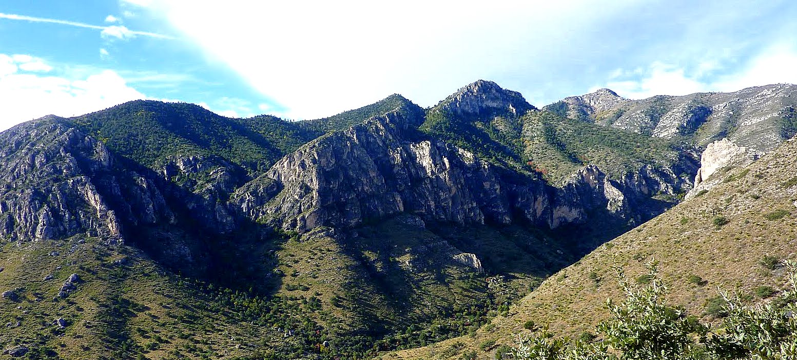
I knew what to expect though…I am very familiar with the terrain since I had paid a visit to this beautiful park back in March. However, we car camped and did a day hike up to the Guadalupe Peak. Which, by the way, is awesome…when you look south and see El Capitan's peak a ½ mile off and a few hundred feet below…it's awe inspiring. Also…if you get squirly, you can scramble down a few gullies and make your way to the edge and literally look 1,500 ft straight down…those faces are huge and intimidating but freakin awesome. This trip called for us to ascend up to Pine Top via Tejas Trail and over to Bush Mountain on the first day...the trail was rocky, arid, and one switchback after another...


(There were a few bends in the trail that was rocky and steep)

(If you look closely, you can see the trail and how it switchbacked...)
…we started at 9 a.m. on Friday morning. We started on the Tejas trail and our goal was to make it to Bush Camp near Bush Mountain. The TH start is at Pine Springs TH, elevation 5,734 ft. Bush Mountain is at 8,631 ft and exactly 6.2 miles from TH. This is an elevation gain of 2,897 ft. The views were great...but, for those who know…hiking with 50 pound packs, going 6.2 miles, and climbing 2,897 ft is (you fill in the blank)! This was a long day of hiking...we stopped several times, we ate, complained, but kept going...


Funny thing is...we felt great when we reached Pine Top...just look at us in the picture below:

We thought we were close to Bush Campsite...we were waaayyy wrong...the next two miles were some of the most difficult miles we've ever hiked. Especially after spending the first part of the day just getting to Pine Top...I don't have any pictures form Pine Top to Bush. Why? Because I didn't care anymore...I just wanted to get to camp...the trail kept going up and down...Every time I got up another hill, I would look down in disappointment...once again, no campsites. So I'll just skip this part of the trip and move on to the next...that is, all of us dying in our tents...exhausted, sore, cold. Good news was we had a radio and could hear the ALCS, game clinching game for our Texas Rangers...We were all excited about this game. But in the end...we were all too tired to care. Just look at Josh below:

Good news though, we completed the hardest segment of our trip. Day 2 and 3 would consist of relatively easier elevation minus and gain and our packs would weigh less due to obvious consumption of water and food. Day three is going downhill the entire way…
Day 2 we hiked the west ridge of the Park on the Bush trail. The views out there are incredible…however, this has to be the windiest part of the park. The winds were howling…we were exposed quite often, but the views were completely worth it. If you ever have the opportunity and wherewithal to get to this point, you will be treated to awesome views of the foothills thousands of feet below and the salt basins west of the mountains.

As we continued on our day 2 hike…we descended into/near the famous bowl. We were treated to beautiful fall colors. Red/orange/golden maple leaves surrounded us the entire time we were on Tejas Trail as we made our way to Pine Top. We also stopped for lunch along the way...


Also, note that these mountains have two sides…On the south face it's Arid mountain-rocky and desert vegetation. On the northface of these mountains...you could not tell if you were in Colorado or in Texas anymore. Pines and Pines and Pines!!!!!! We camped at Pine Top on day 2 and were treated to the best dusk colors in Texas.

Dinner was great, the fellowship even better, but Josh's candy stash was the best!


Day 3…we were all running out of water and we booked it out of there as quickly as we could.

This was a great trip...and I believe what made it great was the group of guys I was with. I'm glad they were with me...their company in the mountains were the best part of the trip.
Comments
Post a Comment