Buffalo National River

All animals need water to live...simple law of nature. The more water there is...the chances of survival go up...Where there is an abundant water source, there is food and drink. For many animals in the wild, this simple law dictates their movement. Where the lakes and rivers go, the animals go. There is no question to life!...You want to survive, follow the creeks, streams, and rivers!
Jesus said to her, "If you knew the gift of God, and who it is that is saying to you, 'Give me a drink, you would have asked him, and he would have given you 'living water." John 4:10
"Everyone who drinks of this water will be thirsty , but whoever drinks of the water that I will give him will never be thirsty again. The water that I will give him will become in him a spring of water welling up to eternal life." John 4:13-14
Jesus was at the well with the Samaritan woman when he revealed to her who he is and the gift he offers to us all. Jesus tells us that he brings "living water" and that it is a gift of God...and that all you have to do is ask him for it and he will give it to you! You see, Jesus is the source of life! He is our river...And just like the animals swarm to the river for life and continue to go with the river to live, we need to swarm to Jesus and continue to go with him to spiritually survive!
Jesus says that whoever drinks of the water he gives, will never go thirsty again. The water he gives will become "in him a spring of water welling up to eternal life." This is one of the most wonderful and amazing promises that Jesus gives! He is telling us that if we drink the water he gives, that God will come to live in us through the Holy Spirit. That God will fill us with His life through the Holy Spirit...and even more, God will cleanse and transform us by His Spirit. God will forever quench our thirst with the Holy Spirit that Jesus gives. He is our river...he is our source of life! Amen!

Who: Sarah Pasquel (celebrating her 30th b-day), yours truly, Oliver (our pooch)
When: 12/29/11-1/1/12
total miles hiked this trip: 28.7 miles
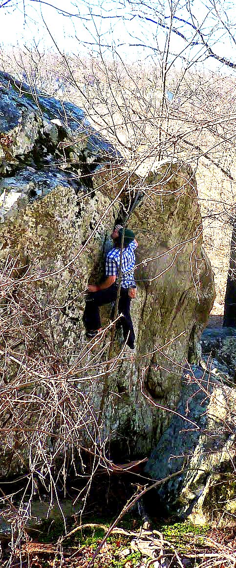
Boulder at Horsehoe Canyon Ranch
Sarah and I drove up from DFW area to Northwest Arkansas to celebrate her 30th birthday and enjoy the outdoors. The plan was to hike the area trails and do a little bouldering at Horseshoe Canyon Ranch. We did not backpack any of the trails, though there are many places you can backpack. Especially the Buffalo River Trail, which we dayhiked a few segments of. We decided to take it easy and enjoy the outdoors by car camping only. We found our pad site a few miles outside of Jasper, AR. It was flat and had great views...this is the tent we used:

12/29/11-Hawksbill Crag (or aka Whittaker Point)
3 miles
It took us about 7 hours to get to the TH. It is a busy TH...since this hike is popular, but completely worth it. At the TH, there is this large carved boulder thanking some politician...but once you see it you know you are there...


This Crag is impressive. Especially when you get out on it. You get clear views of the surrounding valley. The rock is solid and you never really feel any exposure...unless you get right up to the edge. Which of course I have to do.
Right next to Whittaker point is another outcrop, not as impressive as Whittaker point, but still neat...

At this point, we hiked out and knew we were going to be in for a great few days. As we drove back down to the valley, we drove up on this meadow and found a herd of Elk. It was great. They are beautiful animals.

12/30/11
Centerpoint TH to Hemmed in Hollow via Centerpoint trail-Ponca Wilderness (We took a wrong turn though...)
Little over 11 miles
2500' total elevation
7 hours on trail

This is the map we used for this hike. Nowhere on this map does the goat's trail show up. Nor does Big Bluff area...which is pretty significant information to have when on this trail. But I will get to that further down. So we started out at Centerpoint TH and headed East on an old mountain country road. Really, it was just a wide dirt and rocky trail. We knew we were in for a very long day since we were hiking over 10 miles and dropping 1250 ft down to the river. The first 2.5 miles of the hike are straighforward, slowly dropping in elevation. BTW, this is our dog Oliver...he did great.

At about 2.5 miles, we arrive at a backcountry site and a fork in the trail. On the map, there is no fork. Both trails led down. One trail had a yellow blaze and the other trail was not marked. Everything about this situation should tell you to take the trail that is marked...but no, instead I decided to take the umarked trail because I thought both trails would most likely end up at the same place somewhere down the river (I was both right and very wrong). Besides, the unmarked trail looked like it led to some nice views whereas the blazed trail looked like it headed down more of the same woods. For now, it looked like I made a good choice...within a few minutes, this was our first view:

We kept on hiking along bluffs and overlooks. We were on what looked like a nice and well traveled trail so we felt confidant. We got to the end of the trail and found this neat cave/nook area with a hole in it.

This was probably the first time we started to sense something was not right. We wondered if this was the end of the trail since we could no longer see more trail from this point on. Another clue...we were still hundreds of feet above the river...that one kind of gave it away. We looked at another piece of information we had (not on the map) and learned that we were most likely on the Goat's trail that led to Big Bluff. So we figured we must have been at Big Bluff at this point. It was pretty, but nothing too awe inspiring...Sarah mentioned turning around and going back to the fork. I looked down and I thought I saw more of the trail. I went down and went back behind the hole you see in the picture above and found more trail. We kept on going on the goat's trail...and boy, I am glad we did. We ended up seeing great views of the Buffalo National River...

The trail was clear and we continued on it...and lo and behold, we found Big Bluff. Now this bluff was impressive.

The ledge was relatively narrow, but it's definitely not thin enough to deter you from crossing over. You are cognizant of each step though, and if you have a fear of exposure...well, this trail is not for you. After you cross, the trail follows along under more bluffs and a heavily wooded area...

We continued on what we thought was a trail for about 10 more minutes. Then we came to another fork...We already knew we were not on any trail marked on the map...so we just used our sense of direction. We turned left on the fork and headed down the canyon. Sure enough, the trail slowly disappeared into the fallen leaves. Sarah mentioned turning back around. At this point, there was no way I was turning back and going all the way up. We were maybe a few hundred feet above the river ( I could hear it) and knew that we could follow the river down to our destination. We made our way down without too much problem. The problem was, we didn't know exactly where on the river we were (We had no topo map of area on us). However, I did know to follow the river and would have had a good idea as soon as we hit a bend in the river. We got to the first bend and we saw a old horse trail that led into a river crossing. We crossed the cold river, hiked about .25 miles around looking for marked trails and found nothing. We crossed the river again and took a few steps up on the bank and found that wonder yellow blaze!!!! We hiked on the blazed trail that hugged the river and met up with the original trail...

So here's another thing that really chapped us...nowhere on the TH map or in the guide we had did it mention several water crossings. That, or we just skimmed over this piece of information completely. We were in for a cold afternoon! We ended up crossing the river 5 times to equal 10 total water crossings!

If we knew this, we would have had water shoes...which whould have helped tremendously...But it's not like the rocks on the bottom of the river hurt us. Our feet were so numb within seconds of being in the water, we really couldn't feel the pain of the river bottom as much as the pain of the cold! After the first few crossings, we were still in good spirits and didn't let this bother us too much...but still

We ran into a few young guys backpacking the Buffalo River Trail who told us this was the last crossing towards Hemmed in Hollow. We believed them...and so were soooo disappointed when we came across more river crossings. And these crossings were higher and faster. I mean fast moving!!! Check it out: This is Oliver and I within our first few steps:

Now look at Oliver after a few seconds of the picture above...and consider he is paddling as hard as he can to keep up with me!

We put our shoes back on and headed North towards Hemmed in Hollow. Within 10 minutes, we came to another water crossing just like the one above. Sarah and I knew...we were done. It was another mile up to Hemmed in Hollow (2 miles round trip back to this point), we were running out of time, and quite frankly...we knew we still had a few crossing on the way back. We were done. We decided to turn back around and take the right trail back up to the TH.
We both do not regret taking the trip we took on this day. We enjoyed all of it...and we would have missed the Big Bluff if we stayed on the right trail. So we definitely did not regret taking the goat's trail all the way down. However...if you do want to stay on the right trail...just follow one simple rule. It's really easy...just follow this:

12/31/11
Horseshoe Canyon Ranch (HCR)
Climb (Bouldering)

HCR is a working duderanch that doubles as a climbing destination. Which is evident when you drive down the canyon and you see all the sandstone walls all around you. And if that's not enough, when you walk into their main office...you see every climbing manufacturer sticker around and all of the gear they sell. From ropes, to all kinds of pro, and shoes. This place is where climbers come! The sandstone is solid and it's the first place I have ever climbed where I got physically tired of climbing before my hands got too raw too climb! The stone is textured, but it's soft...this place is awesome. These are a few pics of the day.


12/31/11
Hemmed in Hollow via Compton TH
5 miles
1300' total elevation
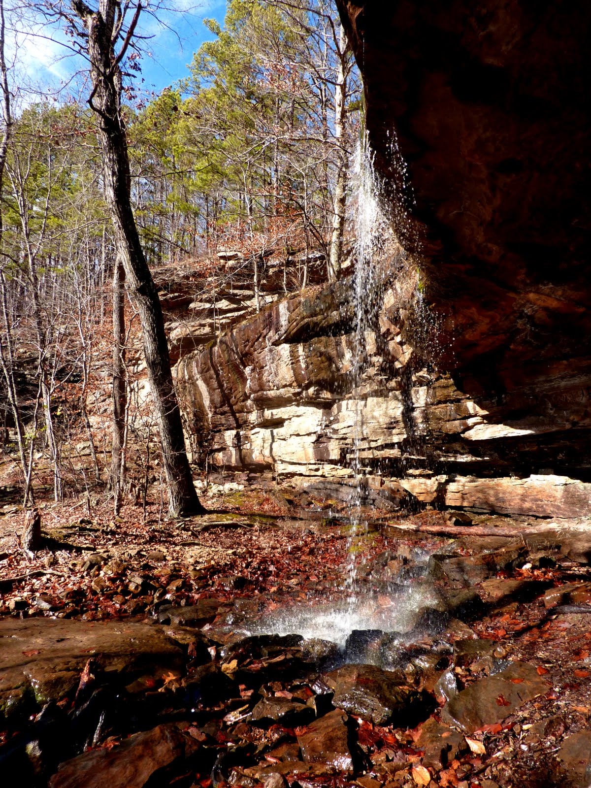
So, since we did not arrive to our destination of Hemmed in Hollow the day before, we decided to get down there this afternoon after climbing at HCR. We were excited about seeing this waterfall we heard so much about. It is said that it is the tallest waterfall between the Rockies and the Appalachian Mountains. And after the day before, there was no way we were leaving without seeing this great waterfall...
So with all of this build up, we were very disappointed when we got to hemmed in hollow and found nothing.

Sure, the hollow was great...even beautiful...but we were expecting a waterfall. We found nothing. But then we looked up...and there it was!!!

You see it? Huh...do you? Exactly...that's how we felt. Very anticlimactic...we felt robbed. It was nothing but a trickle off the cliff. I'm sure when there's plenty of water this watefall is impressive. But today...it was nothing but a joke. Oh well...the trek down was still worth it. We enjoyed the day.
1/1/12 New Year's Day
This day did not go according to plan...but it worked out!
Buffalo River Trail
2 miles
We got down to the TH at Ponca entrance and found that Oliver (Dogs) is not allowed on this trail...

We were bummed out...we put oliver back in the car, rolled windows down, and left him...we got 1 mile down and I felt bad. We left him back at the tent the day before and I knew he wanted to come outside. He was excited to be with us..at first and then you can see his disappointmentwhen we put him back in the car. It was eating at me on the trail. So we stopped and went back for him. We left the BRT.
Lost Valley Trail
3.5 miles

So we took Oliver to Lost Valley and hiked this trail. This place is really cool. If you are in the area, you have to stop here and check this place out.

The trail is very well marked with white blazes, wide, and very scenic. You hike in about a mile and you first come up on Natural Bridge...


Then you go past Natural Bridge and on the way to Eden falls, you walk by this enormous bluff/cave area called Cobb Cave. It was hard to figure out how high this bluff went up and how deep...

As you pass this bluff, you come up on Eden Falls

The falls is about 70 ft high. You hike up the trail and it takes you to Eden Falls Cave...water runs out of this cave and feeds the watefall.

What's really cool about this trail is that all of these sites are in succession. Literally one right after another. The entire hike was easy, fun, and a lot to look at. We also finished it in under two hours which meant:
I got to go back to HCR for a little bit more bouldering. I had to go back at least one more time and climb these awesome blocs.


Buffalo River Trail (Steel Creek TH to Big Bluff look out via BRT)
4.2 miles
This was our last hike of our trip. Earlier in the day we got on the BRT for a mile but it didn't work out due to no dogs allowed. So we dropped off Oliver at the tent and we came back to check out the trail. I really wanted to get on this trail since I know I will return to backpack this trail. The trail is marked with white blazed and it is easily identifiable...even with all the fallen leaves. The trail goes up and down and gains and loses elevation quickly. We just hiked 2.1 miles in before we felt like we were losing light. So we turned back around. This is a view of Bee Bluff nad the Buffalo River from an overlook. There are views after views on this trail. It is really beautiful out here.

We got back down to Steel Creek Landing and made coffee. These are what the bluffs look like from down low...

We got back into the car...drove over to Ozark Cafe (or Pizza on the Square) don't know which one it's called...maybe both...ordered pizza, burgers, and pie. We had a great time. Sarah and I played hard during the day and relaxed at our really nice tent in the evenings. All in all, it was a great way to ring in the new year and celebrate Sarah's 30th birthday. We will return to this beautiful area soon!
Comments
Post a Comment