...continuation of our Zion trip...
Zion National Park: Narrows
Who: Sarah and I
When: 7/15/12
Distance: Little over 8 miles round trip
Duration: 6:17 hrs

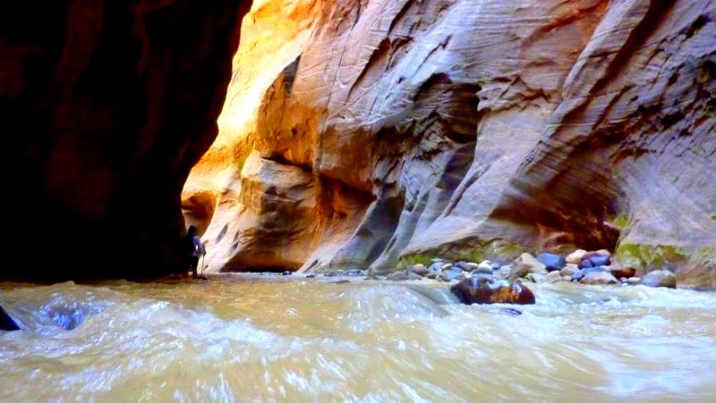
The Zion Narrows actually begins as the Riverside trail at the end of the Canyon's Northern end. The shuttle will drop you off at the Temple of Sinawava, a natural amphitheater that serves as the gateway for all of the dayhikers entering into the Narrows. Sarah and I got on the 2nd shuttle leaving the Watchman Campground/Visitor's Center...and it takes about 20 minutes or so to travel up the Canyon to our destination. The Shuttle makes several brief stops along the way...stopping at the Museum, Canyon Junction, Court of the Patriarch's overlook, The Zion Lodge/Emerald Pools Trailhead, The Grotto, Big Bend, Weeping Rock, and finally Temple of Sinawava. When Sarah and I got off the shuttle, we walked over to the trailhead and to our disappointment, we found a sign stating the Narrows were closed due to High Flash Flood Watch. This didn't necessarily mean you couldn't enter the Narrows...you could. Matter of fact, the Park Rangers and the Park are very straightforward about the risks you take in Zion. They remind you over and over again that..."your safety is your responsibility." Nonetheless, Sarah and I were not going to take the risk on High Flash Flood Watch. Though we were disappointed, we still decided to hike the 1 mile Riverside trail to see where the Narrows began.

So this would be the end of the trail for us...Looking upstream, we both knew that this was the main reason we came to Zion. We wanted to hike/wade the Narrows. Earlier in February of this year, when we were planning our Zion trip, we tried to reserve backcountry permits to hike the entire length of the Narrows. Unfortunately for us, they were already booked. I couldn't believe it...we were 6 months out and all the backcountry sites on the river were booked. My first thought was, "who are all these crazies...seriously man!?" Yeah...didn't take me long to realize I am just like the rest of them...only difference is I am a late. So as Sarah and I let go of the dream and started making our way back down the trail, we saw a group of folks heading upstream with wading boots and poles. We stopped them and asked if something had changed with the flood watch...they said no. Surely, more and more people hiked past us in the opposite direction...we knew something had changed. As we approached the trailhead, we saw no sign...the Park had removed the sign and downgraded the High risk to Moderate Risk. Sarah and I just hiked 2 miles...but we both knew...we were on the same page...we turned around and started our way back towards the Narrows.

After hiking a little over an hour...we finally entered the water and started wading. The water is cold! It varies in height, flow, and clarity. But it constantly remains cold. In regards to the flash flooding...it's always a risk in these slot canyons. All you can do is minimize the risk you are taking...always be vigilant of the sights and sounds of the river...and pray to dear God that He spares you from the flood on this day. During a flash flood, the water rises within seconds or minutes because the water comes from everywhere...During heavy rains, the river water swells instantly from all the tributary streams and water runoff from up above that feed the Virgin River. Thunderstorms miles away from Zion can lead to flash flooding in the slot canyons...really, there are many ways the canyons can swell up. Flooding is not the only hazard either...rock fall is imminent. Sarah and I heard what we thought was thunder...but minutes later, we were informed by other hikers that there was rock-slide activity ahead and to be sure we were hugging the overhung walls when we could. Let's just say this...as I was hiking the Narrows, I always felt a heightened sense of awareness that I usually only reserve while climbing. I gave it more respect...especially since we were spending our time in Zion during the monsoon season of the Southwest. But be assured, I would do this hike again 100x over...it was a blast and I will recommend it to anyone. I will backpack the entire 16 mile top to bottom Narrows trail one day. And one day soon. I already know two people that are on board with me...

After wading about 5 minutes from the end of the Virgin River trail, you come up on this water feature...Mystery Falls. It falls from 40 ft above you...maybe even higher up. It was a pretty cool site to see and only the beginning of things to come for us...however, immediately after passing Mystery Falls,
the water began to rise. Here, Sarah pauses and contemplates her next move. Within the next several steps, the water would rise to her chest. Cold, cold water...I could not take a picture of this section since it would risk damaging the camera. But I'm sure you can find pictures online of people swimming through...
So after the initial baptismal of the Narrows, the water levels drop off to shin and knee high water and go back and forth from hiking on rocky shores to wading in the water as you see above. The walls skyrocket above you but they do not enclose on you as they will the further you go along the trail.
Here, Sarah demonstrates the approach we took for most of the trail. We typically hugged the walls from rockslide/fall protection and it usually was the most shallow part of the river. I of course, for the sake of the picture...crossed the river and exposed myself to death for this great picture. Not really...it was perfectly safe. We hadn't heard any kind of thunder in half an hour or so...
As you can imagine...the Narrows are not very straight. They are like most rivers, typically bending and moving in the direction of least resistance. Over time, the Virgin River carved these magnificent walls in the same shape as itself. So as you continue up stream, you see these enormous walls bend left and right... changing in degree of steepness...and shadow and light moving along the walls. This place is special!

If you day hike this trail there are a few things you would like to know. For starters, if you do not have a permit, you can only go so far. I believe the farthest you can go is 2.5 miles up...to the Big Spring area. There is side canyon you can explore before reaching Big Spring. A mile past Mystery Falls, Orderville Canyon will be to your right. As the main trail...you can only go so far before needing a permit. Sarah and I chose not to explore this side canyon, since we really had no idea how long it would take us to go upstream. Also, the narrows are very popular. So be prepared to share this hike with many people. The good news is...after the first 1/4 mile of entering the trail...just slightly past Mystery Falls...people start turning back around. So the farther you go up, the less and less people you see. Sarah and I got to the point where it was just us for several minutes at a time. So if you are looking for solitude, just keep going farther.


As you near mile #2, from the start of the Narrows hike (mile #3 from Virgin River TH)...you enter slot canyons. The entire hike up...the canyon walls are no wider than 50 yds or so. But at this point...the walls close in at anywhere from 10 to 20 yrds apart. The water color changes from brown to this pretty cloudy aquamarine...and more noticibly, the steady swift smooth river transforms to these small white water rapids. The slots we saw are amazing...but I understand the slots are even more narrow and dramatic some several miles upstream. If you have a permit to hike this trail from the top-down...the narrows in the first few miles are even more impressive. I can't imagine seeing slots more wonderful than the ones we saw...but they are there...further up. Just incredible!
Here is an example of how quickly the water is moving within the slots...there was plenty of white water on this trail...
Here are a few recommendations for this hike:
1) Have sturdy closed toe boots. You step on plenty of slick rock and you need all the protection you can get. There are wading shoes you can rent from the park...but Sarah and I chose to wear our boots instead and felt fine. Do not wear sandals...you will stub your toe over and over again.
2) Poles! They are a must if you want to move at a decent pace. In the beginning of the trail, we saw many hikers without them...and sure enough, they moved a lot slower and did not get as far. The water current is very swift...very strong. I will admit, even with poles, I fell a few times and was completely immersed in the water. I couldn't imagine how many falls I would take without them.
3) Dry bags. You need to protect your camera and gear. Having your stuff in waterfproof sacks is essential if you care about having dry layers, dry equipment (i.e. camera), and not eating a soggy sandwich. You will get wet. There is no avoiding it...and you will remain wet the entire time you are on this trail. You never dry off...
Sarah and I continued upstream...we knew how long we had hiked that day...and knew it would take us the same amount of time to get back. We didn't have any idea how long we hiked...since I was not carrying a GPS. I was trying to do my best to calculate...but had no clue. It felt like we hiked for miles and miles...but reality is, we had only gone a little over 3 miles from the original TH. My usual hiking pace is 3 mph...today it was a little over 1 mph. Wading in water will slow you down...

We did not get much farther than the picture above. Matter of fact, I later learned that we were within a few hundred yards of Big Spring. It's a shame we didn't go that much farther, since there are waterfalls in Big Spring. But Sarah and I had no clue where we were. There are no signs or landmarks once you enter the slots to let you know how far you are going. You also lose sense of distance with all those turns. I felt like there were only so many bends when looking at a map. But when you are in the canyon, every little turn feels like a bend...and sure enough, my count was 2-3X more than what the map indicated. So we turned around...and enjoyed the canyon we came up on.
Side notes:
-We hiked the 1 mile roundtrip trail of the lower Emerald Pools on this day. There was no water flowing this day...so I did not take any pics.
-We also hiked the .5 mile roundtrip trail to hanging gardens of Weeping Rock. This area was lush and the water literally seeped out of the rock. Unfortunately, there was not one picture I took than could capture the beauty of this place. I failed you!
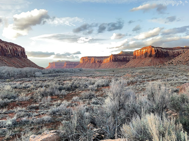
-The next morning, right before we left for Telluride, CO...we hiked the 1 mile roundtrip scenic overlook trail to see the higher peaks of the canyon. I completely recommend this trail. There is a hundered or so feet of elevation, so it's not too difficult. It's located up the canyon, back through Carmel Tunnel and to your left. When you reach the end of the trail...you get a panoramic view of the canyon big walls and their higher peaks. (which I posted in the previous post, but will do again here.)
Up next: Telluride, Colorado...Via Ferrata...and more!!!!


Comments
Post a Comment