 Who: Brad Hardin and myself.
 What: Climb Organ Needle via Class 3 Normal Route
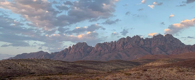
Where: Organ Mountains Desert Peaks National Monument
When: April 3, 2021
Why: A print that was given to us by my father n law, that hangs in my house, has been staring at me for a long time. It's been calling me.

Organ Needles Trail (not maintained by park service)
5.8 miles RT...but feels much longer and your GPS/watch/smart phone will say you hiked 10+ miles from all the bushwhacking, navigating, scrambling, turning around, getting lost, etc, etc, etc. 5.8 miles, maybe, if you take every correct step. Otherwise, plan for longer.
Start time 7:15am
Summit 10:45am
45 minutes on Summit
Back to car 2:15pm
Total time: 7 hours
Elevation gain: 3,562'
CAUTION: Rated toughest hike in New Mexico. But it wasn't too bad. If you know your landmarks, don't mind a little bushwhacking, and you are comfortable with Class terrain, this will not just be a tough hike...it will be an awesome day out.
TH: Started out at La Cueva Picnic Area. This is my google map I created for this trip. As you can see, I pinned the landmarks as reference points.
This is the trailhead sign.
First 3/4 mile of the start of the hike, you will take La Cueva Trail and hike to the left and behind the crags. The Trail will continue East behind the Crags.
...then you will see this gate. Enter it, and take Filmore Canyon Trail for about 0.2 miles...
until you see this split. The trails sign to the right takes you to Filmore Canyon Spring. You want to continue on the left, up towards the gray rocks. The trail climbs up and you will be hiking above the canyon in a NE direction...
and you will come to an overlook of the Spring below.
Once past Springs Overlook, you will continue up the trail, slowly gaining elevation through what seems like boulder fields and sharp as knifes desert plants. Watch out for these guys...they will poke you. In addition to these desert plants, there is cactus everywhere. Highly recommend wearing pants and long sleeves...even if it is warm. You will get scratched, poked, and stabbed on this hike from these plants. If you start your hike in the morning, you'll get to see the desert peaks shadows on the desert valley floor.
As you continue up the trail, there will be a junction for Modoc Mine Trail. This trail goes left, down into a ravine. But for Organ Needle trail, just continue straight. From below, your landmarks are in front of you. The initial two landmarks we used are the Yellow Rocks and the Grey Eminence. The trail goes directly to the right of the yellow rocks and crosses a gully, continues up and to the left of Grey Eminence. The Grey Eminence is a large Grey wall. As you get closer to it, it is an obvious feature on the hike.
Yellow Rocks are to the left of Brad...
Trail below and around Grey Eminence...
From below the Grey Eminence, you can see The Wedge's West ridge...(This was our objective for Day 2)
After hiking/scrambling past Grey Eminence, you arrive at Juniper Saddle. At this point, you have gained nearly 2200' feat of elevation. You can clearly see the Organ Needle above to the right. From Juniper Saddle, continue East...
Near 8,000', you will see this slab...you will continue up this gully...
A rock with 8K, indicating elevation...
Above Juniper Saddle...the trail is marked with red blazes, pink or blue ribbons. Just continue to find these blazes, the trail seamed obvious to us. These blazes will guide you through the Dark Canyon up to
Southwest flank of the Needle and a narrow cliff known as "The Retaining Wall". When you reach the top of the Dark Canyon saddle, there will be maple trees. Scramble, bushwack through maples on trail until...Mountain Project describes this section as, "At the top of Dark Canyon, a small saddle is passed and you drop down on the east side of the mountain to find the right gully which will take you to the top. Approximately 100ft from the saddle is a corner system which can be scrambled up. Near the top of this is a 15 ft section of exposed rock which must be surmounted to reach the summit. A narrow dike provides good hand and foot-holds, and it is no harder than 3rd class, but it involves some good exposure.On our hike, there was a blue rope, with overhand knots tied in...
We chose not to use the rope and traverse the class 3 section. Picture above shows the terrain. Once past the class climb...it's a 5 minute romp to the top!


Comments
Post a Comment