Mt. Whitney Mountaineer's Route Trip Report

David was in no hurry to hide from God, he knew it was impossible to do so. He was rhetorically/hypothetically asking in the psalms...knowing that God is everywhere, in every situatuation, in every aspect of life. There is nowhere you and I can go to escape His presence...nowhere at all!
This trip, I experienced all kinds of highs and lows...literally. I stood atop the highest point in the contingous United States (Mt. Whitney at 14,505 ft) and the lowest point in North America (Badwater Basin in Death Valley National Park at 282 ft below sea level) within a day or so. In between, there were many other highs and lows...from high ridges, colouirs, and alpine lakes down to canyons, valleys, and basins. Of course, there were all other kinds of terrain in between...a roller coaster of elevation gain/loss that screwed with my internal equilibrium.
I kept finding God in all these places. From the High Sierra walls, the 100 foot pines, all the way down to the salt flats of the lowest deserts. It was all incredible, and easy for me to revel in the Creator. But then it got me thinking...this small adventure is a metaphor to everyday life, but unlike finding God in creation, sometimes it's more difficult to see Him in our everyday.
Most of us feel like we are somewhere on the mountain on any given day...Of course there are days we are on top of the mountain and days we are struggling down in the valley. But overall, we find ourselves in the routine of everyday. Get up, get kids ready for school, go to work, work, come home, dinner, and do it all again tomorrow. In this painfully numbing process, it's unfortunately easy to lose sight of God...though He is right there. On the same token, life also has it's ups and downs, and God is still present in these moments. God is there when you are on the summit, God is there when you are making your way up or down the mountain, God is there when you are tucked away...hidden in the mountain, and God is there when you are down in the valley. God is everywhere.
In other words, God is there when you get that raise or promotion, God is there when your kids graduate to the next grade, God is there when your marriage is on the rocks, God is there when you are hiding that addiction, and God is there when you hit rock bottom. God is always there.
Furthermore, if we are purposefully hiding from God or just not thinking about Him at all...God is still there. He always has been and always will be.
Just like on Mount Whitney and in Death Valley, God is everywhere in my life...There is not one dark place I can make my bed without God making the night shine like the day! And this brings me comfort! To know that God is there, ready to meet me in all areas of life...ready for an encounter with me anywhere on the mountain. God is there, always present, and more importantly...waiting to meet me when I get that raise or promotion, when my kids move on to the next grade, when my marriage is struggling, when I am hiding that addiction, and when I hit rock bottom. God is always there, ready to guide me and hold me fast! Amen!

Who: Jeremy Hendrix, Brad Hardin, and Ugly (me)
What: Climbing at Alabama Hills
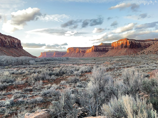
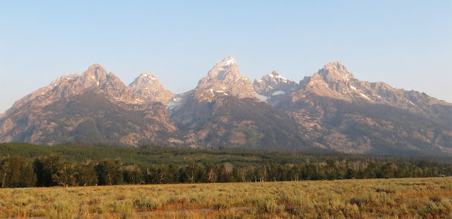
We left for California from my house in Texas, by car, and drove 20+ hours to get to Lone Pine, CA to climb the infamous Mt. Whitney (in picture above, it's the summit on the right side...which looks lower because it's way back there). Our permits to enter Inyo National Forest were set for 9/11/12, so we spent this day acclimatizing in town, at the Whitney Portal at 8,300' and doing a little climbing at the Alabama hills (That's me above, lead climbing the Shark's Fin Arete).

The Alabama Hills are a range of gnarly rock formations in the foothills of Mt. Whitney. They are composed of huge, granite blocs that make up a wonderful foreground of the Eastern Sierras. Many of you have actually seen these hills and have never known it...This location is a very popular Hollywood site for filming. There have been 150 movies and a dozen shows filmed here over the decades. Popular films include Gladiator and Iron Man...In picture above, Brad is belaying Jeremy on anothor route of the Shark's Fin.


Who: Brad, Jeremy, and I
What: Mt. Whitney Mountaineer's Route (MR)
Mileage: 12 miles roundtrip
Elevation gain: 6,100 ft.
Class III

9/11/12
The TH begins at 8300' at the Whitney Portal. Here you will find this gazebo with topo map of trail, guidelines, and a scale to weigh your pack. We weighed in as followed:
Me: 35.5 lbs
Jeremy 35.5 lbs
Brad: 37 lbs
I would say this is a little heavier than we would like for a backpacking trip that doesn't require carrying all your water, but the bear canister (that is required in this forest) is almost 2 pounds and we were carrying extra food in the case we were staying up there an extra day.

Both the Mountaineer's Route (MR) and the Whitney Trail share the same start for the first 20 minutes in. It's on a very easy, maintained trail that switches up and back above the Whitney Portal. If you are doing the MR route, you have to know that it is an unofficial trail, not maintained by the US Forest Service. It really is a climber's trail that has been established by a century of approaches into the base of Whitney...though it is easy to follow if you are paying attention, it looks nothing like the picture above. It is rocky, uneven, and in many places...loose and dirty. But we'll get to that later...

So after those first 20 minutes...you come up to this sign (junction). It is right before a water crossing. If you continue straight on this trail, you will remain on the Whitney Trail. However, if you are doing the MR route, you need to stop here and look to your right and then look up. The trail is fainter than the trail you are on...but it's good. One other thing that always threw me off about this sign in other trip reports is the sign itself...it always looked to me that the sign pointed left...Forget how the sign is shaped. It points nowhere! Just look up and to the right...that's they way you want to head.

After heading up to the right, you know you are on the right trail when you come up on this sign...it's within a minute of the junction...now you start the MR route!


After the sign, you start hiking up the canyon via the North Fork of the Lone Pine Creek. The Trail is an established climber's trail that crosses the creek twice. The trail is rocky and steadily ascends towards the base of the Ebersbacher Ledges (E-Ledges). As seen above, the canyon bottlenecks and tightens up as you ascend. The E-ledge landmark you are looking for at this point is the lone Pine tree that rises our of the rock. If you see the picture above, I am hiking up and if you look directly above me, you see a lone pine sticking out of the slab...You want to head in this direction. The scramble up the E-Ledges begins right under this pine.

As you continue to make your way up...you get a better view of the E-Ledges. If you look closely, you see a tiny hiker in the middle...the Lone Pine Tree mentioned previously is on the left side.

When you arrive to this point, a water crossing and a small waterfall...you have arrived to the base of the E-Ledges. It took us 1:15 hrs from the TH to get to the base of the E-Ledges. At this point, there are a few class 3 moves to get up over onto the slabs...


The Pine Tree you see above is the same one pictured and mentioned before...


The E-Ledges are a series of ledges on the side of the Canyon that look like a huge slab from the canyon floor...The ledges will get as narrow as two feet wide (as pictured below) but for the most part are wide enough to feel somewhat comfortable traversing across and over. Make no mistake...exposure is very high so be very careful with you steps and remain calm and balanced throughout this section of the hike.

After we completed the E-Ledges, we took a break in the trees above the E-Ledges and ate a snack...from this vantage point, you can see a better view of the remaining route up to Lower Boy Scout Lake. Though you can't see the lake yet, you know it's up above ahead of you.

On this particular day, the clouds started moving in...we knew there was a chance of a thunderstorm, but our main objective was to get passed the E-Ledges before it poured on the slabs. As you can see above, the Canyon narrows as you move on up...

As you make your way up to Lower Boy Scout Lake, you stay on the right side of the canyon as you move up. There is no other option...you pretty much hug the walls to the right and you continue to hike on a very rocky and loose trail. As mentioned before, the trail is easy to follow...but not easy to hike.

After getting to the top of the canyon, we came up on a creek crossing, crossed it...and got our first views of LBSL. It's a small lake with large pines surrounding the lake on the South Side. You can set up camp here if you like...the lake sits at over 10,300' and you have officially hiked over 2000' from the TH. But for many who pursue Whitney, the preferred campsites are up above even higher...at Upper Boy Scout Lake or even Iceberg Lake. For flatlanders like ourselves...our destination on day 1 was to set up basecamp at Upper Boy Scout Lake (UBSL).

The MR route continues past the LBSL on the South Side through the large pines you see above. But this is where the route gets tricky...you come up on a large boulder field. We learned there are several routes up this scree. It also doesn't help that there are cairns that lead you in every which way. On the way up, we took a trail that led us a feww hundred feet above the lake on loose rock...though we were following a trail, it just didn't "feel" right. Later on, we concluded we must have been following a climber's trail to another route that is found here. There are several big walls to climb at this junction of the canyon.

This is where we ended up...or I should say, this is where cairns led us to. Can't be right, right? This look slike a death trap to me...

Here's my advice on this section of the route...when you hike around the lake...look up the scree field and you will see these two huge boulders. The one on the left is a house-sized boulder. Keep these boulders in your view (really, they will always be in your view). The two best options are to either go in between the two or under the one on the right. On our way back down, we took a trail that had cairns, that led us under the boulde ron the right...and it nearly hugged the willows all the way down to the lake.

The willows and this trickling waterfall will be to your right on the way up...you want to stay as close as possible to the willows and waterfall. Then you will go up and under the big boulders and this will spit you right out onto the slabs that lead up to UBSL. This is the route you want to take...if you go up to high like we did...you will end up way too high, and will have to bushwack through willows later on. You dont want to do that...

So this is where you want to be...on the slabs that are above LBSL and below UBSL. These slabs are slick, with water running down them. In the winter, they are iced over with packed snow...in the Summer, it's wet...however, there are dry spots and that's how you determine your route...the picture above does not give you a good indication of the slope. It is steadily rising and it will make your thighs scream...

After 4 hours, we finally arrived to camp...Upper Boy Scout Lake. Keep this in mind...We are flatlanders, that took our time, stopped for snack and lunch, took wrong route in scree field, bushwacked through willows, and took many pictures...taking it all in. So 4 hours may not mean much...to the hiker who is humping it.

This is our camp...at 11,350'. Above treeline...clouds down low...breezy...awesome!

This is view of the opposite side of the lake...not sure, but it looks like Lone Pine and the Owens Vally below may have gotten a little bit of rain...or at least that dry rain they talk about. Where it evaporates before it hits the ground. Who knows, doesn't make sense to me...

Jeremy and I enjoying the evening...
Up Next:

Summiting Whitney!!!!!
Comments
Post a Comment